Volume II, Book 2:
Making It Clear: The Importance of Transparency
Sandra Lach Arlinghaus
sarhaus@umich.edu
http://www-personal.umich.edu/~sarhaus/
Volume I of the Spatial Synthesis* series focuses on theory;
Volume II* of the series focuses on applications, turning theory into practice.
|
TABLE
OF CONTENTS
These chapters use subtle effects and reflect the importance of transparency in making concepts become clear. |
INTRODUCTION Graphics created on the computer often employ subtle capabilities that did not really exist in a paper and pen environment. Thus, "white" becomes a color to be used in the same way as red or green. "Transparent" also becomes a color by which to uncover parts of other images. Two dimensional maps composed of layers in Geographic Information Systems software may look through one layer to see part of another. Images created in Adobe Photoshop can be assigned partially opaque colors to let still others show through. The world of three-dimensional models suggests a host of oppotunity for making things "clear." The emphasis in this second book in Volume II of the Spatial Synthesis is on the importance of transparency. |
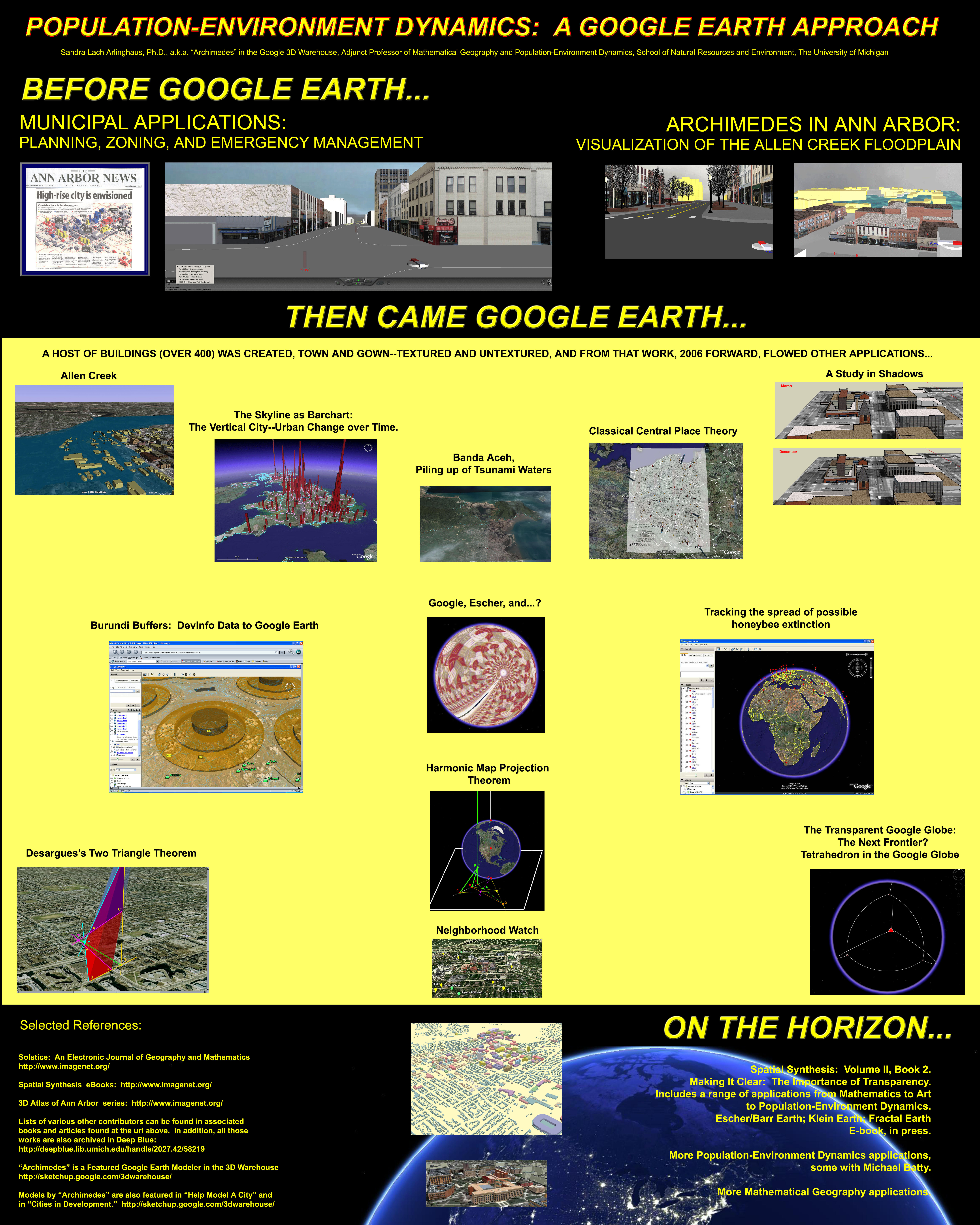
| A visual annoted bibliography of previous related applications appears below. In the figure, click on an image (including the Earth at night) to go to related links. Author names appear on linked materials. These images link to electronic materials internal to the Institute of Mathematical Geography (IMaGe). Individual articles contain links to citations to a variety of materials. A poster based on this image was presented at the first "Scientific Applications with Google Earth Conference," October 22-23, 2008, at The University of Michigan, Ann Arbor. (Link to full-sized poster presented by the author.) |
 |
*2005: Book. Spatial Synthesis, Volume I:
Centrality and
Hierarchy. Book 1. Arlinghaus, Sandra Lach and
Arlinghaus,
William Charles. June 21.
2008:
Book. Spatial Synthesis, Volume
II, Book
1. Scientific, Planning,
Humanitarian, and
Teaching Applications, From DevInfo to Google Earth.
Arlinghaus,
Sandra
Lach, et al.
Software
used
for analysis:
- DevInfo
5.0:
http://www.devinfo.org/
- Adobe® PhotoShop and ImageReady
- Adobe® DreamWeaver
- ESRI:
- ArcView® 3.2
- ArcGIS® 9.2
- ArcCatalog®
- ArcMap®
- Google Earth®
Author
affiliation:
Arlinghaus, Sandra Lach. Adjunct Professor of Mathematical Geography and Population-Environment Dynamics, School of Natural Resources and Environment, The University of Michigan. Executive Committee Member (Secretary) Community Systems Foundation, sarhaus@umich.edu, http://www-personal.umich.edu/~sarhaus/
Arlinghaus, Sandra Lach. Adjunct Professor of Mathematical Geography and Population-Environment Dynamics, School of Natural Resources and Environment, The University of Michigan. Executive Committee Member (Secretary) Community Systems Foundation, sarhaus@umich.edu, http://www-personal.umich.edu/~sarhaus/
Published by:
Institute of Mathematical Geography
http://www.imagenet.org
http://deepblue.lib.umich.edu/handle/2027.42/58219
October, 2008.
Copyright by Sandra Arlinghaus, all rights reserved.