Volume II, Book 1:
Scientific, Planning, Humanitarian, and Teaching Applications, From DevInfo to Google Earth
ASSESSMENT--AFRICA
FIGURE 5.3: Animation. The goal of this sequence of images is to suggest other ways to edit and save files in Google Earth so that they appear in Google Earth when it is opened again after having been shut down.
 |
|
|
FIGURE 5.3: Static frames of the
animation. The
goal of this sequence of images is to suggest other ways to edit and
save files in Google Earth so that they appear in Google Earth when it
is opened again after having been shut down.
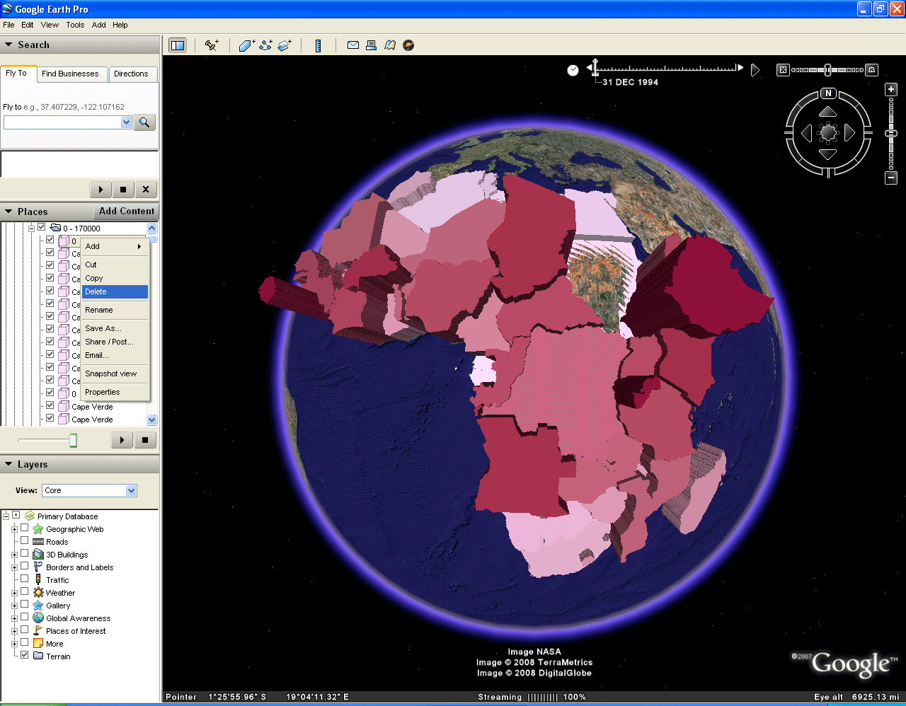
 FIGURE 5.3a: Begin with last frame of Figure 5.2. Open up the folders to find the 0 entries. Right-click on a 0 entry and click on "Delete." This action will delete the unwanted entry permanently (whereas simply unchecking it hid it only temporarily). |
|
 FIGURE 5.3b: Because the deletion is permanent, you will be asked to be sure you wish to delete the entry. |
|
 FIGURE 5.3c: Delete all entries of zero. The result appears above and it will remain in this form even when reopened (because deletion was permanent). |
|
 FIGURE 5.3d: This file is already located in the "My Places" folder. To save it in a location of your choice on a hard drive, go to "File" and then "Save." Notice that the "Save to My Places" option is grayed out because the file is already located there. |
|
 FIGURE 5.3e: Click on "Save Place As." |
|
 FIGURE 5.3f: Save it where you wish on your hard drive. Give the edited file a different name from that of the raw file. Edited files are supplied below for each of the variables for which there is data. The method of editing may vary from one to another (some temporary, some not, depending on what is shown and the nature of the structure of the associated database). |
|
|
TABLE OF CONTENTS
- INTRODUCTION: Assessment, Analysis, and Action--Community Systems Foundation Approach
- ASSESSMENT:
Software
used in analysis:
- DevInfo
5.0: http://www.devinfo.org/
- Adobe® PhotoShop and ImageReady
- Adobe® DreamWeaver
- ESRI:
- ArcView® 3.2
- ArcGIS® 9.2
- ArcCatalog®
- ArcMap®
- Google Earth®
Author
affiliations:
- Arlinghaus, Sandra Lach. Adjunct Professor of Mathematical Geography and Population-Environment Dynamics, School of Natural Resources and Environment, The University of Michigan. Executive Committee Member (Secretary) Community Systems Foundation, sarhaus@umich.edu, http://www-personal.umich.edu/~sarhaus/
- Naud, Matthew. Environmental Coordinator and Assistant Emergency Manager, Systems Planning Unit, City of Ann Arbor
- Oswalt, Kris S. President, Community Systems Foundation
- Rayle, Roger. Scio Residents for Safe Water
- Lars Schumann. Manager and
Research Computer Specialist, University of Michigan 3D Laboratory at
the Duderstadt Center; also of Cornell University, Ithaca NY
- Arlinghaus, William C. Professor of Mathematics and
Computer Science, Lawrence Technological University, Southfield, MI
- Arlinghaus, William E. General Manager, Chapel Hill Memorial Gardens, Grand Rapids, MI
- Batty, Michael. Bartlett Professor of Planning and Director of the Centre for Advanced Spatial Analysis (CASA) at University College London
- Haug, Robert. Ph.D. Candidate, Middle Eastern and
North African Studies, The University of Michigan
- Larimore, Ann Evans. Professor Emerita, Residential College, The University of Michigan
- Longstreth, Karl. Head, Map Library, The
University of Michigan
- Nystuen, Gwen L. Parks Advisory
Commission; Environmental Commission;
City of Ann Arbor
- Nystuen, John D. Professor Emeritus of Geography and
Urban Planning, Taubman College of Architecture and Urban Planning, The
University of Michigan. Chief Executive Officer, Community
Systems
Foundation
Published by:
Institute of Mathematical Geography
http://www.imagenet.org
http://deepblue.lib.umich.edu/handle/2027.42/58219
August, 2008.
Copyright by Sandra Arlinghaus, all rights reserved.