Volume II, Book 1:
Scientific, Planning, Humanitarian, and Teaching Applications, From DevInfo to Google Earth
ACTION
 Source: Visualizing Rank and Size of Cities and Towns. Solstice: An Electronic Journal of Geography and Mathematics, Volume XVII, Number 2, 2006, Sandra L. Arlinghaus and Michael Batty. See related material below. |
- Selected Current Applications
- Municipal Scientific Applications--Matthew Naud and Roger Rayle
- M. Naud--Argo Dam removal and Google Earth
- Publication in Solstice: An Electronic Journal of Geography and Mathematics, Volume XIX, Number 1. Huron River Tour, Ann Arbor
- Communications with professional hydrologists in an effort to integrate the contemporary electronic capability within the traditional hydrological settings often presented to municipal authorities.
- R. Rayle--Wells on the west side of Ann Arbor: update from 2007: Use of spreadsheets and Mail Merge with Google Earth.
- Presentation notes,
October 11, 2008.
- Publication in Solstice: An Electronic Journal of Geography and Mathematics, Volume XIX, Number 1. Google Earth Applications in a Community Information System: Scio Residents for Safe Water
- Population-Environment Dynamics Planning Applications--Sandra Arlinghaus, Matthew Naud, Gwen Nystuen, and John Nystuen
- S. Arlinghaus, G. Nystuen, J. Nystuen: Continued modeling of the Ann Arbor CBD following up on the efforts presented in the linked materials below--
- 3D Atlas of Ann Arbor, 1st Edition. Editor and principal author: Sandra Lach Arlinghaus with co-authors noted throughout. June, 2006.
- 3D Atlas of Ann Arbor, 2nd Edition. Sandra Lach Arlinghaus, November, 2006.
- 3D Atlas of Ann Arbor, 3rd Edition. Sandra Lach Arlinghaus with input from others noted throughout. June 2007.
G.
Nystuen suggests that the City of Ann Arbor should commission
(for a
fee) the modeling of the effects of changes to the zoning
ordinance as
currently proposed. That idea would "sell" the idea of
work
already donated for this purpose to the Downtown Development
Authority
and the City of Ann Arbor in 2004 and chronicled in both the
Ann Arbor
News and in a linked article: Arlinghaus, Beal, and
Kelbaugh: The
View from the Top: Visualizing Downtown Ann Arbor in
Three
Dimensions. J. Nystuen notes that, since 2004, we
are now
faced with the unintended extremes that had been mere
possibilities in the past but are now proposed under the Cxx
zones as
amended in 2006. A new zoning scheme is proposed in which the
D1D2
zoning replaces all Cxxx zones. It would be interesting to
zoom around
in the virtual Ann Arbor world to show some possible scenarios
that
could occur under the new D1 and D2 zones. The results would
be
dramatic--all the more so today than in 2004 (and earlier
presentations
of similar material) when 3D modeling was so new that it was
difficult
for all but a handful of municipal authorities to appreciate.
- S. Arlinghaus and M. Naud: Continuing analysis
of 3D
flood population-environment models.
This work follows up on
earlier
analysis present in the 3D Atlases of Ann Arbor (linked
above) and also
in models present in the Google SketchUp 3D Warehouse.
See the Collections
by
Archimedes (pseudonym of S. Arlinghaus). Many of
Archimedes's models have achieved "Blue Ribbon" status and
are
therefore part of the default set of materials in Google
Earth
(Archimedes is also a "Featured Modeler" in the 3D
Warehouse).
Other models can be downloaded directly from the 3D
warehouse.
- Live Feed Humanitarian Applications--Lars Schumann and Kris Oswalt
- K.
Oswalt:
- Throughout a lot of the developing world, each time a water engineer applies for reimbursement for drilling or maintaining a village well, the lat/lon coordinates are recorded. This is in lieu of giving the bore well a name and to avoid "duplicate billing". Thousands of wells are under construction, repair, maintenance, etc. It would be very interesting to map this. The data (lat/lon and status of the well) might be captured by SMS over cell phone since most of the engineers have cell phones in these areas.
- School teachers in Uganda are using cell phone technology to send in answers to 6 key questions on a regular basis. It would be interesting to map this in real time as the number of schools increases in the network.
- Emergency field workers could be tracked while doing initial rapid assessments in the first 72 hours after an emergency.
- L. Schumann:
- Magic Bus. Publication in Solstice: An Electronic Journal of Geography and Mathematics, Volume XIX, Number 1. Real-time Animation Scripts for Google Earth
- Existing work of 3D Lab in Emergency Management
- Ongoing Teaching
Applications--Sandra
Arlinghaus, Robert Haug, Ann Larimore, and Karl
Longstreth
- S.
Arlinghaus. R. Haug, A. Larimore and K. Longstreth:
- Maps, Timelines, and the Internet: the Quest for Peace in the Middle East: Ann E. Larimore with Sandra L. Arlinghaus, Robert Haug, and Karl Longstreth. An existing course structure developed by Larimore is now in its third year of classroom use (2005, 2007, 2008). The future might see the integration of DevInfo data (live-feed or otherwise) in this web-based approach that integrates space and time using maps and timelines; it already employs Google Earth in a scientific/teaching mode. Related articles:
- Ann Evans Larimore with Sandra Lach Arlinghaus and Robert Haug, A Methodology for Historical Geography: Internet Implementation Solstice: An Electronic Journal of Geography and Mathematics, Volume XVI, Number 1, 2005.
- Sandra Arlinghaus, Robert Haug, Ann Larimore Lewis and Clark, 200 Years: A Visual Tribute to an Exploration. The Gates of the Rocky Mountains. Solstice: An Electronic Journal of Geography and Mathematics, Volume XIV, Number 2, 2003
- S.
Arlinghaus:
Continuing
work with Ph.D. and other students in a one-on-one setting
to teach
them to integrate new software, particularly those that
permit the
visualization of 3D images, with their own data. The
primary
method
used at present is to analyze the data in ESRI's ArcMap and
export the
results to Google Earth using the strategy set forth in this
document.
- Directing the Past toward the Future
- Scientific Applications
- Integration of
software: Atlas 2008,
Sandra L. Arlinghaus and Kris S. Oswalt. Extension of the
processes in this Atlas to
the entire DevInfo database perhaps with integration
of technique into
DevInfo or related software.
- Data
Compression:
- Sandra L. Arlinghaus
and
Michael
Batty. Solstice:
An
Electronic Journal of Geography and Mathematics,
Volume XVII, Number 1. Zipf's
Hyperboloid?
Use
by
the first author to develop ideas of hyperbolic
geometry realized on
the Poincaré
Disk and interpreted on the sphere. Suggested
realization of ideas using data of second author
involving rank-size
changes over time. This first article led to a
series of
others. It might well lead to other
projects involving
DevInfo with
integration of interests from London to Ann Arbor to
New Delhi using,
perhaps, the interface of non-Euclidean geometry.
- Sandra L. Arlinghaus and John D. Nystuen. The Animated Pascal Sandra Lach Arlinghaus, Solstice: An Electronic Journal of Geography and Mathematics, Volume XVIII, Number 2. This article includes the Google Earth sphere draped with one of Escher's "Circle Limit" series (realized using the Poincaré Disk) thus reinforcing visualization of the origins of the Escher art with material associated with data compression and hyperbolic geometry. John Nystuen noted the utility of rotating the sphere to bring data into view at different scales--so that what was once small and in the distance becomes large and up close as the sphere is rotated.
- Planning Applications
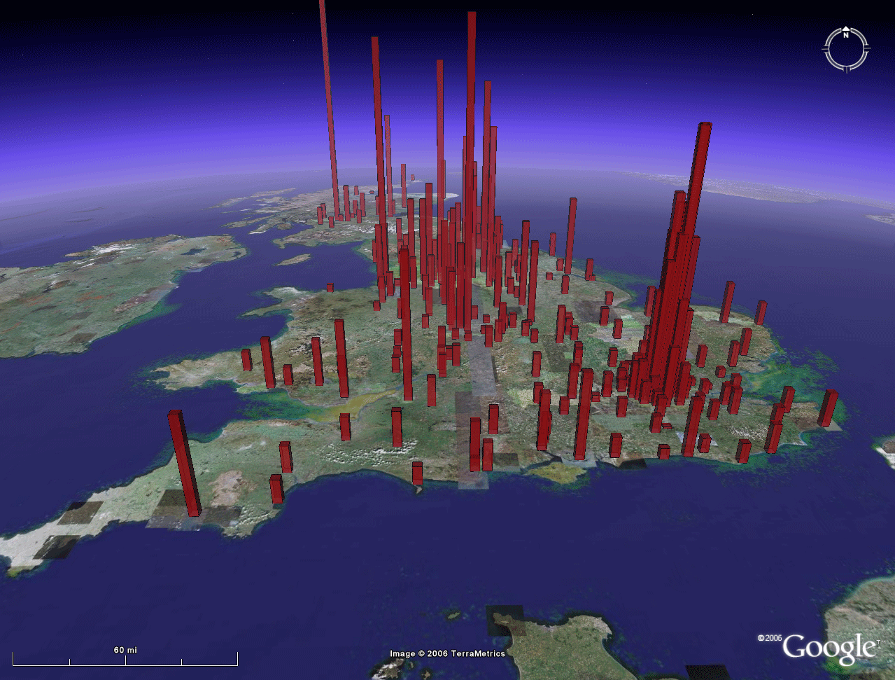
- Visualizing
Rank
and Size of Cities and Towns.
Solstice:
An
Electronic Journal of Geography and Mathematics,
Volume XVII, Number
2, Sandra
L. Arlinghaus and
Michael Batty. See figure at top of this page
from this source.
- Part I: England, Scotland, and Wales, 1901-2001
- Part
II:
Greater London, 1901-2001
Here,
Arlinghaus extended work done with Google Earth Ann Arbor
tall
buildings (housed in the Google 3D Warehouse as
"Archimedes") in
seeing the patterns they create as Google Earth "bar
charts"
Batty supplied the needed data from his comprehensive set to
run
preliminary tests of this scientific application in
population-environment dynamics.
- Visualizing a Map of Walter Christaller, Poland 1941. Solstice: An Electronic Journal of Geography and Mathematics, Volume XVII, Number 2, Sandra Lach Arlinghaus.
- Part I: Benchmarking the Map.
- Part II: Interpolation of the Benchmarked Map.
This
scientific/planning application of Google Earth draws
concepts from
classical cartography into the rich environment of Google
Earth.
In so doing, it derives strength from far-flung earlier work
involving
3D modeling of mathematical, scientific, and envisioning
concepts.
- Continuation
of Spatial Synthesis Series of E-Books: Sandra
L. Arlinghaus and
William C. Arlinghaus. Volume I, Book 1 dealt
with theory
primarily and set the stage for continuation in Volume
I of theoretical
developments through multiple "books." Volume II
is devoted to
application--turing theory into practice. Links
related to
material in both volumes are listed below. Many
others appear on the website of the Institute
of Mathematical Geography (Deep Blue link
to
archive of IMaGe) both in the E-Books section and also
in Solstice:
An Electronic
Journal of Geography and Mathematics
(Pirelli INTERNETional Award Semi-Finalist, Top 80 of
over 1000
worldwide entries).
- 2007: Solstice (all by S. Arlinghaus). Special Issue on Projective Geometry Constructions; Geo/metry/graphy -- Visual Unity; Desargues's Two-Triangle Theorem.
- 2006: Solstice. Banda Aceh: A View on the Globe; 3D Atlas of Ann Arbor: The Google Earth Approach, Part I; 3D Atlas of Ann Arbor: The Google Earth Approach, Part II.
- 2005: Book. Spatial Synthesis, Volume I: Centrality and Hierarchy. Book 1. Arlinghaus, Sandra Lach and Arlinghaus, William Charles. June 21.
- 2005: Solstice. Sandra Lach Arlinghaus Spatial Synthesis,The Evidence of Cartographic Example: Hierarchy and Centrality ; Sandra L. Arlinghaus et al. Kioskland: A Strategy for Linking Hierarchical Levels of Virtual Reality Maps ; Sandra Lach Arlinghaus, Spatial Synthesis: Investigations in Progress
- 2004: Solstice. Sandra Lach Arlinghaus and William Charles Arlinghaus. Spatial Synthesis Sampler. Geometric Visualization of Hexagonal Hierarchies: Animation and Virtual Reality. This article finished as a "Semi-finalist" in the Pirelli INTERNETional Award Competition (top 80 of over 1400 worldwide entries).
- 2004: Solstice. Sandra L. Arlinghaus, Fred J. Beal, and Douglas S. Kelbaugh The View from the Top: Visualizing Downtown Ann Arbor in Three Dimensions . An image from this article was featured on the front page of the Ann Arbor News.
- 2004:
Solstice.
Klaus-Peter
Beier, One
Optimization of an Earlier Model of Virtual Downtown
Ann Arbor.
- 2003: Solstice. Sandra Lach Arlinghaus, Spatial Syntheiss: 3D Atlas of Ann Arbor; Sandra Arlinghaus, Michael Batty, and John Nystuen, Animated Time Lines: Coordination of Spatial and Temporal Information; Sandra Lach Arlinghaus, Ann Arbor, Michigan: Virtual Downtown Experiments; Sandra Lach Arlinghaus, Tornado Siren Location: Ann Arbor, Michigan (this work was featured in the Ann Arbor News). Also, Sandra Lach Arlinghaus, Ann Arbor Michigan: Virtual Downtown Experiments, Part II; Taejung Kwon, Adrien A. Lazzaro, Paul J. Oppenheim, Aaron Rosenblum Ann Arbor, Michigan: Virtual Downtown Experiments Part III.
- 2002: Book. Sandra L. Arlinghaus, William C. Arlinghaus, Frank Harary. Graph Theory and Geography: An Interactive View E-Book, John Wiley and Sons. This book was Wiley's first eBook.
- 2002:
Solstice.
Sandra
Arlinghaus, Salma Haidar, and Mark Wilson,
Animated
Map Timeline, Syria; Sandra L. Arlinghaus and
William C.
Arlinghaus, Spatial
Synthesis: A Research Program.
- Humanitarian Applications
- Development of Live Feed in association with Google Earth and humanitarian projects involving DevInfo and CSF work are in progress. The mechanism is in place with dedicated server space including cgi capability. Experiments with PERL are underway.
- Perimeter Project--Sandra L. Arlinghaus, William E. Arlinghaus, and Kris Oswalt. Lands on which people are buried are among those most highly protected by law and tradition in many societies. This work would involve a collaborative effort to identify valued lands (often "perimeter" lands) and protect them using established attitudes toward the status of burial grounds. "Green" cemeteries already do preserve broad swaths of land. There are over 200 of them in Great Britain and a handful in the U.S.A. To date, they are present only in developed nations. The collaboration here might involve working with a land trust and the state (or similar entities) as well as with scholars and local authorities with expertise in burial tradition. It might involve a special form of DevInfo (ConservInfo?) to manage records and to engage in networking involving burial practice in relation to land conservation throughout the world. DevInfo currently affords opportunity for data collection related to protection of the world's people--why not also to the protection of the world's lands? The records might be tracked in Google Earth, with live feed. Members might receive virtual memorialization (trust-funded and assigned permanent urls) through established collaborative effort. Amalgamation of desirable parcels would become an interesting challenge and might draw constructive insight from various planning strategies. Michigan's perimeter lands might serve as a pilot project to develop systematic strategy to extend elsewhere. The word "perimeter" refers not only to the obvious interface between land and water but also to more subtle interfaces...indeed, even to one between life and death!
- Teaching Applications
Maps
and Decisions: an existing course
structure (developed by S. Arlinghaus) in which
the underlying philosophy is that the decisions we make
influence the
maps that we make AND that the maps we make influence the
decisions we
make. The future might see the development of more
than course
material, possibly employing DevInfo data (live-feed or
otherwise) in
the existing Internet environment.
Related article, Sandra Lach Arlinghaus Maps
and Decisions: Allen's Creek Floodplain,
Opportunity or Disaster?
Solstice: An
Electronic Journal
of Geography and Mathematics,
Volume XIII, Number 1, 2001. The methods developed
in this
earlier course extend into current teaching strategies,
as well.
TABLE
OF CONTENTS
- INTRODUCTION: Assessment, Analysis, and Action--Community Systems Foundation Approach
- ACTION:
Software
used
in analysis:
Published by:
Institute of Mathematical Geography
http://www.imagenet.org
http://deepblue.lib.umich.edu/handle/2027.42/58219
August, 2008.
Copyright by Sandra Arlinghaus, all rights reserved.
- DevInfo
5.0:
http://www.devinfo.org/
- Adobe® PhotoShop and ImageReady
- Adobe® DreamWeaver
- ESRI:
- ArcView® 3.2
- ArcGIS® 9.2
- ArcCatalog®
- ArcMap®
- Google Earth®
Author
affiliations:
- Arlinghaus, Sandra Lach. Adjunct Professor of Mathematical Geography and Population-Environment Dynamics, School of Natural Resources and Environment, The University of Michigan. Executive Committee Member (Secretary) Community Systems Foundation, sarhaus@umich.edu, http://www-personal.umich.edu/~sarhaus/
- Naud, Matthew. Environmental Coordinator and Assistant Emergency Manager, Systems Planning Unit, City of Ann Arbor
- Oswalt, Kris S. President, Community Systems Foundation
- Rayle, Roger. Scio Residents for Safe Water
- Lars Schumann.
Manager and
Research Computer Specialist, University of
Michigan 3D Laboratory at
the Duderstadt Center; also of Cornell
University, Ithaca NY
- Arlinghaus, William C. Professor of
Mathematics and
Computer Science, Lawrence Technological University,
Southfield, MI
- Arlinghaus, William E. General Manager, Chapel Hill Memorial Gardens, Grand Rapids, MI
- Batty, Michael. Bartlett Professor of Planning and Director of the Centre for Advanced Spatial Analysis (CASA) at University College London
- Haug, Robert. Ph.D. Candidate, Middle
Eastern and
North African Studies, The University of Michigan
- Larimore, Ann Evans. Professor Emerita, Residential College, The University of Michigan
- Longstreth, Karl. Head, Map Library, The
University of Michigan
- Nystuen, Gwen L. Parks Advisory Commission;
Environmental Commission;
City of Ann Arbor
- Nystuen, John D. Professor Emeritus of
Geography and
Urban Planning, Taubman College of Architecture and
Urban Planning, The
University of Michigan. Chief Executive Officer,
Community
Systems
Foundation
Published by:
Institute of Mathematical Geography
http://www.imagenet.org
http://deepblue.lib.umich.edu/handle/2027.42/58219
August, 2008.
Copyright by Sandra Arlinghaus, all rights reserved.