Volume II, Book 1:
Scientific, Planning, Humanitarian, and Teaching Applications, From DevInfo to Google Earth
ASSESSMENT--AFRICA
Download and install "export shape to KML" plug-in for ArcMap 9.2 plus.
- Zipped file
- Link to external download page
FIGURE 4.2: Animation. The goal of this sequence of images is to show the reader how to begin to generate a kml file for Google Earth from a choropleth map (ranged fill by data interval) from the edited .apr file extracted originally from DevInfo.
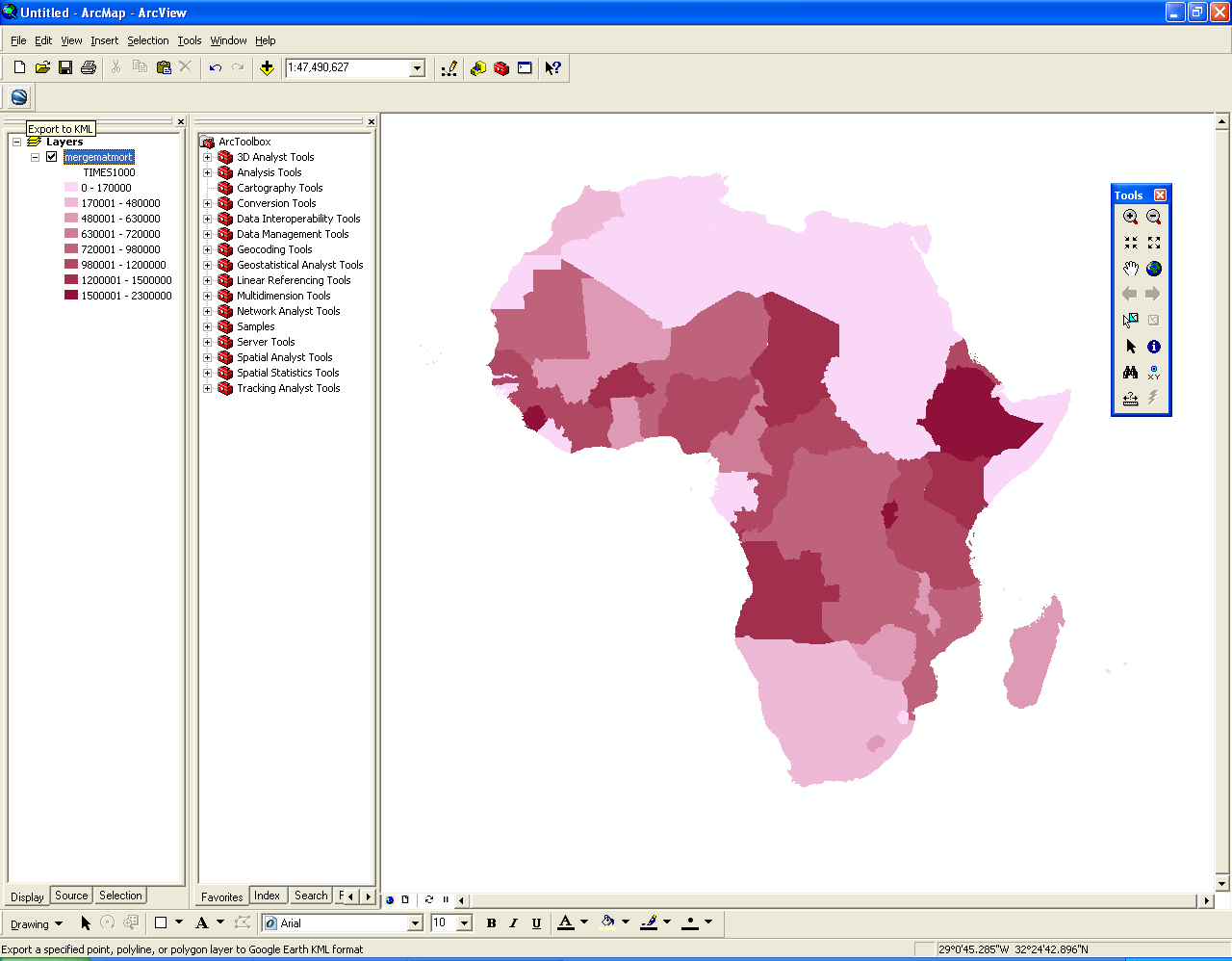 |
FIGURE 4.2: Static frames of the
animation. The
goal of this sequence of images is to show the reader how to begin to
generate a kml file for Google Earth from a choropleth map (ranged fill
by data interval) from the edited .apr file extracted originally from
DevInfo.
 FIGURE 4.2a: Begin with the choropleth map generated in Figure 4.1. Find the icon, upper left, used to generate kml from a shape file. The yellow tag, "Export to kml," appears when the mouse is run over the button representing the installed plug-in (see top of page). |
 FIGURE 4.2b: Open the "Export to kml" button. The window above appears on top of the map. |
 FIGURE 4.2c: Fill in the first pull down with the name of the shape file. |
 FIGURE 4.2d: Fill in the second slot with the country name (or whatever is desired) from the pull down menu. |
 FIGURE 4.2e: Choose "Times1000" as the attribute to represent height in the Google Earth display; this value sets the amount each country will be extruded. |
 FIGURE 4.2f: The table now appears as above. Note that the height attribute units come up, default, as "feet." |
 FIGURE 4.2g: Google Earth is set to "meters" as height units. Thus, click the radio button for "meters" here. |
 FIGURE 4.2h: Finally, fill in the last slot with the location where you wish to store the kml file. Click on the "Browse to file" button. |
 FIGURE 4.2i: Save the kml file wherever you wish. Files may be saved as "kml" = "keyhole markup language" or as "kmz," the zipped form of kml. |
 FIGURE 4.2j: Now the entire table is filled. Do NOT yet click the "OK" button. |
TABLE OF CONTENTS
- INTRODUCTION: Assessment, Analysis, and Action--Community Systems Foundation Approach
- ASSESSMENT:
Software
used in analysis:
- DevInfo
5.0: http://www.devinfo.org/
- Adobe® PhotoShop and ImageReady
- Adobe® DreamWeaver
- ESRI:
- ArcView® 3.2
- ArcGIS® 9.2
- ArcCatalog®
- ArcMap®
- Google Earth®
Author
affiliations:
- Arlinghaus, Sandra Lach. Adjunct Professor of Mathematical Geography and Population-Environment Dynamics, School of Natural Resources and Environment, The University of Michigan. Executive Committee Member (Secretary) Community Systems Foundation, sarhaus@umich.edu, http://www-personal.umich.edu/~sarhaus/
- Naud, Matthew. Environmental Coordinator and Assistant Emergency Manager, Systems Planning Unit, City of Ann Arbor
- Oswalt, Kris S. President, Community Systems Foundation
- Rayle, Roger. Scio Residents for Safe Water
- Lars Schumann. Manager and
Research Computer Specialist, University of Michigan 3D Laboratory at
the Duderstadt Center; also of Cornell University, Ithaca NY
- Arlinghaus, William C. Professor of Mathematics and
Computer Science, Lawrence Technological University, Southfield, MI
- Arlinghaus, William E. General Manager, Chapel Hill Memorial Gardens, Grand Rapids, MI
- Batty, Michael. Bartlett Professor of Planning and Director of the Centre for Advanced Spatial Analysis (CASA) at University College London
- Haug, Robert. Ph.D. Candidate, Middle Eastern and
North African Studies, The University of Michigan
- Larimore, Ann Evans. Professor Emerita, Residential College, The University of Michigan
- Longstreth, Karl. Head, Map Library, The
University of Michigan
- Nystuen, Gwen L. Parks Advisory
Commission; Environmental Commission;
City of Ann Arbor
- Nystuen, John D. Professor Emeritus of Geography and
Urban Planning, Taubman College of Architecture and Urban Planning, The
University of Michigan. Chief Executive Officer, Community
Systems
Foundation
Published by:
Institute of Mathematical Geography
http://www.imagenet.org
http://deepblue.lib.umich.edu/handle/2027.42/58219
August, 2008.
Copyright by Sandra Arlinghaus, all rights reserved.