Volume II, Book 1:
Scientific, Planning, Humanitarian, and Teaching Applications, From DevInfo to Google Earth
ASSESSMENT--AFRICA
FIGURE 3.1: Animation. The goal of this sequence of images is to show the reader how to project the shape files produced in Section 2 so that they might be further processed later in both ArcMap and in Google Earth.
...... |
|
|
FIGURE 3.1:
Static frames of the animation. The
goal of this sequence of images is to show the reader how to project
the shape files produced in Section 2 so that they might be further
processed later in both ArcMap and in Google Earth.
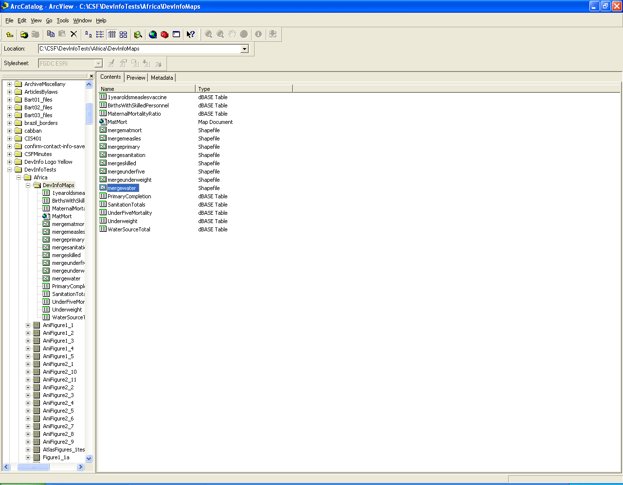
 . .FIGURE 3.1a: Open up ArcCatalog and navigate to where the shape files (merged files for each of the 8 indicators) created in Section 2 are stored. |
|
 FIGURE 3.1b: Right-click on a shape file. Choose "Properties." |
|
 FIGURE 3.1c: The box showing "Details" is empty. That fact says that there is no projection assigned to the map. Click on the "Select" button. |
|
 FIGURE 3.1d: When "Select" is clicked on, the "Browse for Coordinate System" window pops up. |
|
 FIGURE 3.1e: Select "Geographic Coordinate Systems." Double-click on it. |
|
 FIGURE 3.1f: Double-click on "World." |
|
 FIGURE 3.1g: Double-click on "WGS 1984.prj." |
|
 FIGURE 3.1h: Now when you are returned to the "Shapefile Properties" window, you will see that the projection details have been filled in. Click the "OK" button. Repeat the process for each shape file. In the "Resultant Files" below, take four files for each map. |
|
.
|
TABLE OF CONTENTS
- INTRODUCTION: Assessment, Analysis, and Action--Community Systems Foundation Approach
- ASSESSMENT:
Software
used in analysis:
- DevInfo
5.0: http://www.devinfo.org/
- Adobe® PhotoShop and ImageReady
- Adobe® DreamWeaver
- ESRI:
- ArcView® 3.2
- ArcGIS® 9.2
- ArcCatalog®
- ArcMap®
- Google Earth®
Author
affiliations:
- Arlinghaus, Sandra Lach. Adjunct Professor of Mathematical Geography and Population-Environment Dynamics, School of Natural Resources and Environment, The University of Michigan. Executive Committee Member (Secretary) Community Systems Foundation, sarhaus@umich.edu, http://www-personal.umich.edu/~sarhaus/
- Naud, Matthew. Environmental Coordinator and Assistant Emergency Manager, Systems Planning Unit, City of Ann Arbor
- Oswalt, Kris S. President, Community Systems Foundation
- Rayle, Roger. Scio Residents for Safe Water
- Lars Schumann. Manager and
Research Computer Specialist, University of Michigan 3D Laboratory at
the Duderstadt Center; also of Cornell University, Ithaca NY
- Arlinghaus, William C. Professor of Mathematics and
Computer Science, Lawrence Technological University, Southfield, MI
- Arlinghaus, William E. General Manager, Chapel Hill Memorial Gardens, Grand Rapids, MI
- Batty, Michael. Bartlett Professor of Planning and Director of the Centre for Advanced Spatial Analysis (CASA) at University College London
- Haug, Robert. Ph.D. Candidate, Middle Eastern and
North African Studies, The University of Michigan
- Larimore, Ann Evans. Professor Emerita, Residential College, The University of Michigan
- Longstreth, Karl. Head, Map Library, The
University of Michigan
- Nystuen, Gwen L. Parks Advisory
Commission; Environmental Commission;
City of Ann Arbor
- Nystuen, John D. Professor Emeritus of Geography and
Urban Planning, Taubman College of Architecture and Urban Planning, The
University of Michigan. Chief Executive Officer, Community
Systems
Foundation
Published by:
Institute of Mathematical Geography
http://www.imagenet.org
http://deepblue.lib.umich.edu/handle/2027.42/58219
August, 2008.
Copyright by Sandra Arlinghaus, all rights reserved.