Volume II, Book 1:
Scientific, Planning, Humanitarian, and Teaching Applications, From DevInfo to Google Earth
ASSESSMENT--AFRICA
FIGURE 2.6: Animation. The goal of this sequence of images is to show the reader how to fill a database field, in ArcView 3.2/3.3, with data converted to "number" format suitable for using to create choropleth maps.
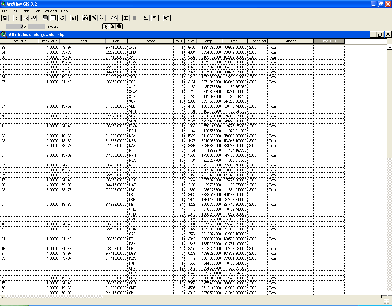 |
FIGURE 2.6:
Static frames of the animation. The
goal of this sequence of images is to show the reader how to fill a
database field, in
ArcView 3.2/3.3, with data converted to "number" format suitable for
using to create choropleth maps.
 FIGURE 2.6a: The screen that remains from the previous sequence. The table is still in editable format. |
 FIGURE 2.6b: Find the "Field Calculator" button (above the yellow tag in the image). Click on it. This wizard will be used to add data to the field that had been added to the database. |
 FIGURE 2.6c: Once the "Field calcultor" choice has been made, the window above will pop up over the database. |
 FIGURE 2.6d: The values we wish to add to the "Times1000" column are contained in the "Datavalue" column. Note that the alignment of the entries in the "Datavalue" column are left-justified indicating that they are "text" entries. The field calculator will be used to copy these into the new column in number format and multiply them by 1000 so they show up well when projected onto a globe later. Click once on "[Datavalue]". Notice the box at the bottom: "[Times1000]"= blank space. In the sequence of images to follow, we will write an equation in the blank space to say what "Times1000" should be equal to. |
 FIGURE 2.6e: Double-click the "[Datavalue]" entry. This action will enter that word into the blank box at the bottom. Notice that the "Type" is now set to "String" indicating that the item just entered is in text format. It will need to be converted to "number" format in order to manipulate it as we wish. |
 FIGURE 2.6f: In the box at the right, "Requests," scroll down to find "AsNumber" and click once on that to select it. This is the command that also will be entered in the equation box to convert from "string" to "number" type. |
 FIGURE 2.6g: Double-click "AsNumber" to enter it into the equation box for "Times1000". |
 FIGURE 2.6h: Type in *1000 in the equation box. Now click the "OK" button. |
 FIGURE 2.6i: The field calculator has now placed the entries from "Datavalue" times 1000 in this column. Note that the entries are now right-justified indicating that they are in number format. |
TABLE OF CONTENTS
- INTRODUCTION: Assessment, Analysis, and Action--Community Systems Foundation Approach
- ASSESSMENT:
Software
used in analysis:
- DevInfo
5.0: http://www.devinfo.org/
- Adobe® PhotoShop and ImageReady
- Adobe® DreamWeaver
- ESRI:
- ArcView® 3.2
- ArcGIS® 9.2
- ArcCatalog®
- ArcMap®
- Google Earth®
Author
affiliations:
- Arlinghaus, Sandra Lach. Adjunct Professor of Mathematical Geography and Population-Environment Dynamics, School of Natural Resources and Environment, The University of Michigan. Executive Committee Member (Secretary) Community Systems Foundation, sarhaus@umich.edu, http://www-personal.umich.edu/~sarhaus/
- Naud, Matthew. Environmental Coordinator and Assistant Emergency Manager, Systems Planning Unit, City of Ann Arbor
- Oswalt, Kris S. President, Community Systems Foundation
- Rayle, Roger. Scio Residents for Safe Water
- Lars Schumann. Manager and
Research Computer Specialist, University of Michigan 3D Laboratory at
the Duderstadt Center; also of Cornell University, Ithaca NY
- Arlinghaus, William C. Professor of Mathematics and
Computer Science, Lawrence Technological University, Southfield, MI
- Arlinghaus, William E. General Manager, Chapel Hill Memorial Gardens, Grand Rapids, MI
- Batty, Michael. Bartlett Professor of Planning and Director of the Centre for Advanced Spatial Analysis (CASA) at University College London
- Haug, Robert. Ph.D. Candidate, Middle Eastern and
North African Studies, The University of Michigan
- Larimore, Ann Evans. Professor Emerita, Residential College, The University of Michigan
- Longstreth, Karl. Head, Map Library, The
University of Michigan
- Nystuen, Gwen L. Parks Advisory
Commission; Environmental Commission;
City of Ann Arbor
- Nystuen, John D. Professor Emeritus of Geography and
Urban Planning, Taubman College of Architecture and Urban Planning, The
University of Michigan. Chief Executive Officer, Community
Systems
Foundation
Published by:
Institute of Mathematical Geography
http://www.imagenet.org
http://deepblue.lib.umich.edu/handle/2027.42/58219
August, 2008.
Copyright by Sandra Arlinghaus, all rights reserved.