Volume II, Book 1:
Scientific, Planning, Humanitarian, and Teaching Applications, From DevInfo to Google Earth
ACTION
Roger Rayle, Presentation Notes, October 11, 2008.
 A 2008 isoconcentration map of Pall-Gelman’s 1,4-dioxane contamination was superimposed in Google Earth. Then dioxane isoconcentration lines were extruded to show magnitude of 1,4-dioxane contamination above 85, 1000, 2000, and 3000 ppb. The Prohibition Zone outline was extruded up to 85 ppb (blue) to show the level at which the dioxane levels would have to be reduced had Michigan’s cleanup standard of 85 ppb been applied in the Prohibition Zone as it has been outside of the zone. The red outline is the well Prohibition Zone where no water wells can be used because of the high levels of 1,4-dioxane projected to move through the aquifers in that area. |
 Since no one is allowed to use the groundwater within the Prohibition Zone, the dioxane levels within the zone now only have to be cleaned up to 2800 ppb, Michigan’s groundwater/surface water interface standard. In contrast to using the 85 ppb cleanup standard, this allows a huge amount of dioxane to escape cleanup and possibly migrate to other areas where groundwater is used. |
 The actual readings for 2008 are superimposed on the 3D map to show that some are much higher than the extruded isoconcentration levels. |
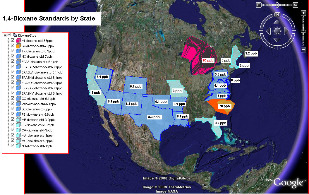 For states that have 1,4-dioxane groundwater cleanup standards, each state was extruded out in proportion to its dioxane cleanup standard. Until 1995, dioxane in Michigan groundwater had to be cleaned up to 3 ppb. In 1995, the dioxane cleanup standard for Michigan was changed to 77 ppb and later to the current 85 ppb… much higher than any other state standard. This is unfortunate since Michigan is steward to 20% of the world’s fresh water. |
TABLE
OF CONTENTS
- INTRODUCTION: Assessment, Analysis, and Action--Community Systems Foundation Approach
- ACTION:
Software
used in analysis:
Published by:
Institute of Mathematical Geography
http://www.imagenet.org
http://deepblue.lib.umich.edu/handle/2027.42/58219
August, 2008.
Copyright by Sandra Arlinghaus, all rights reserved.
- DevInfo
5.0: http://www.devinfo.org/
- Adobe® PhotoShop and ImageReady
- Adobe® DreamWeaver
- ESRI:
- ArcView® 3.2
- ArcGIS® 9.2
- ArcCatalog®
- ArcMap®
- Google Earth®
Author
affiliations:
- Arlinghaus, Sandra Lach. Adjunct Professor of Mathematical Geography and Population-Environment Dynamics, School of Natural Resources and Environment, The University of Michigan. Executive Committee Member (Secretary) Community Systems Foundation, sarhaus@umich.edu, http://www-personal.umich.edu/~sarhaus/
- Naud, Matthew. Environmental Coordinator and Assistant Emergency Manager, Systems Planning Unit, City of Ann Arbor
- Oswalt, Kris S. President, Community Systems Foundation
- Rayle, Roger. Scio Residents for Safe Water
- Lars Schumann. Manager and
Research Computer Specialist, University of Michigan 3D Laboratory at
the Duderstadt Center; also of Cornell University, Ithaca NY
- Arlinghaus, William C. Professor of Mathematics and
Computer Science, Lawrence Technological University, Southfield, MI
- Arlinghaus, William E. General Manager, Chapel Hill Memorial Gardens, Grand Rapids, MI
- Batty, Michael. Bartlett Professor of Planning and Director of the Centre for Advanced Spatial Analysis (CASA) at University College London
- Haug, Robert. Ph.D. Candidate, Middle Eastern and
North African Studies, The University of Michigan
- Larimore, Ann Evans. Professor Emerita, Residential College, The University of Michigan
- Longstreth, Karl. Head, Map Library, The
University of Michigan
- Nystuen, Gwen L. Parks Advisory
Commission; Environmental Commission;
City of Ann Arbor
- Nystuen, John D. Professor Emeritus of Geography and
Urban Planning, Taubman College of Architecture and Urban Planning, The
University of Michigan. Chief Executive Officer, Community
Systems
Foundation
Published by:
Institute of Mathematical Geography
http://www.imagenet.org
http://deepblue.lib.umich.edu/handle/2027.42/58219
August, 2008.
Copyright by Sandra Arlinghaus, all rights reserved.