|
Varroa
(Acari: Varroidae) is a parasitic mite that threatens the extinction of
the
world's honey bee (Apis mellifera) population. This mite not only feeds on bees and bee
larvae, but carries viral diseases and promotes stress to these
hard-working
insects (Sammataro et al., 2000). We
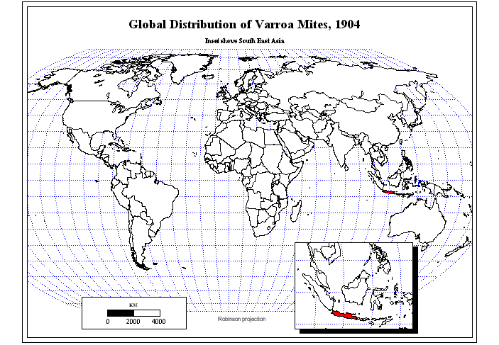
have been mapping the spread of this blight for quite awhile (Figure 1)
focusing on the importance of animation as a tool to draw together
space and
time. Understanding spatial pattern helps
to tighten focus on intervention. There
are obvious consequences associated with the possible extinction of
honey bees:
honey has long been an important agricultural crop (Ellis and Munn,
2005;
Matheson, 1996). In addition, honey bees
are important pollinators of one third of our crops, including fruits
and
vegetables and used in seed production (Free 1993; McGregor, 1976; http://www.sciencedaily.com/releases/2007/05/070510114621.htm). There are substantial economic implications
to the possible demise of bee pollinators as well as to the production
of honey,
long used as a natural sweetener (a healthy alternative to processed
sweeteners) and for medicinal purposes.
The production of beeswax from the honeycomb is even more
valuable, a
primary foundation for cosmetics, as well as for making candles. All of these hive products have been
important since beekeeping was first recorded; wax and propolis
(bee-collected
plant resins) were vital to preserving Egyptian mummies.
Beyond the obvious, when an established
species is removed from an ecosystem it is simple logic that the impact
of such
removal will have long-range, and perhaps unforeseen, consequences.
The
Varroa problem began in Asia in the early twentieth century (Goncalves
et al.
1985; Rosenkranz et al. 2010). Today,
Varroa is found worldwide, with some exceptions (Bradbear 1988;
Matheson 1996)
such as Australia. Erroneous
classification of the mite has clouded some of the reporting of
information. First identified as Varroa jacobsoni on the Asian honey bee Apis
cerana, molecular analysis has now separated
out four different Varroa species. We
refer here, for purposes of mapping, to the mite simply as "Varroa”,
and in
general terms it represents the new Varroa
destructor (Anderson and Trueman 2000) that jumped from the Asian
honey bee
onto the European honey bee (Apis
mellifera). Careful analysis of the
problem as a whole, beyond the tracking aspects, must consider the
taxonomic
problems as well (see Rosenkranz, et al., 2010; Navajas et al., 2010).
As
late as 2000, Varroa was discovered in New Zealand (Matheson 2000), in
Panama
(Calderon et al. 2000) and in St. Kitts & Nevis in the Caribbean. It has also been found in the Caribbean
islands of Grenada in 1994, Trinidad in 1996 (Hallim, M.K.I. 2000),
Cuba in
1996, Dominica in 1998, St. Lucia in 1999, Tobago and Nevis in 2000. It apparently has also been reported in Haiti
(dates forthcoming). On July 6, 2000,
Varroa was first detected in Panama.
The
recent discovery of Varroa mites in the Eastern Rift Valley in eastern
Kenya
(2009), the homeland of the honey bee species as well as a diverse
population
of wild (often unusual) animals, is particularly alarming because bees
and honey
are an integral part of subsistance-level farmers where honey is an
important
source of income. The discovery of mites somewhat earlier (2007) in the
tropical paradise of the remote Hawaiian Islands, will have a huge
impact since
many breeders raise queen honey bees there. The spread of these
mites can be directly
attributed to the movement of bee colonies by beekeepers and as well as
from some
hitchhiking bee swarms on ships. Other
mites are on the horizon which are equally devastating to bee
pollinators.
|
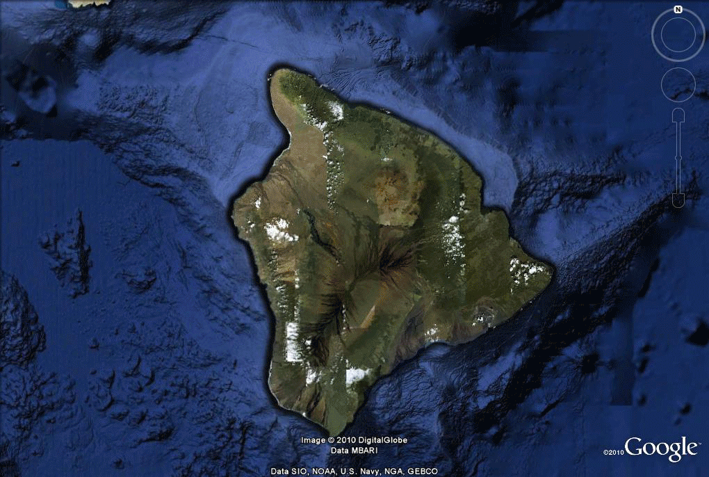 Figure 2.
Hawaii (Big Island). Balloons indicate sites that are part of the
mite inventory. Yellow means "no mites sighted" and red means
"mites sighted."
|
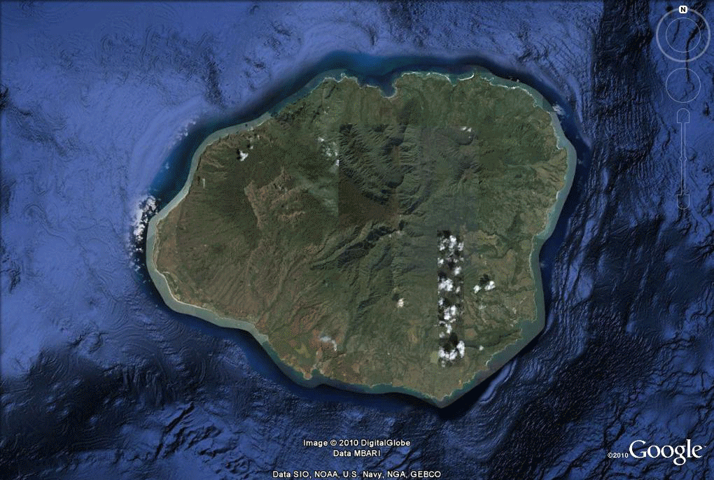 Figure 3. Kauai. Balloons indicate sites that are part of the mite inventory. Yellow means "no mites sighted" and red means "mites sighted." |
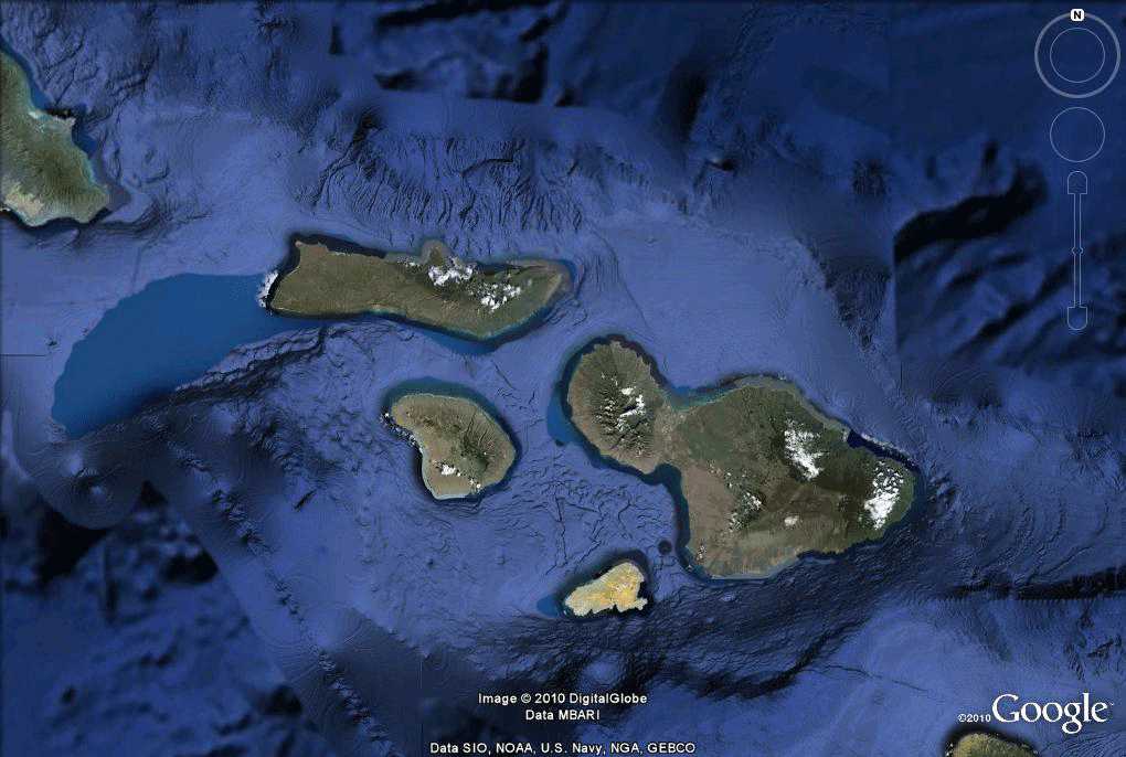 Figure 4. Maui. Balloons indicate sites that are part of the mite inventory. Yellow means "no mites sighted" and red means "mites sighted." |
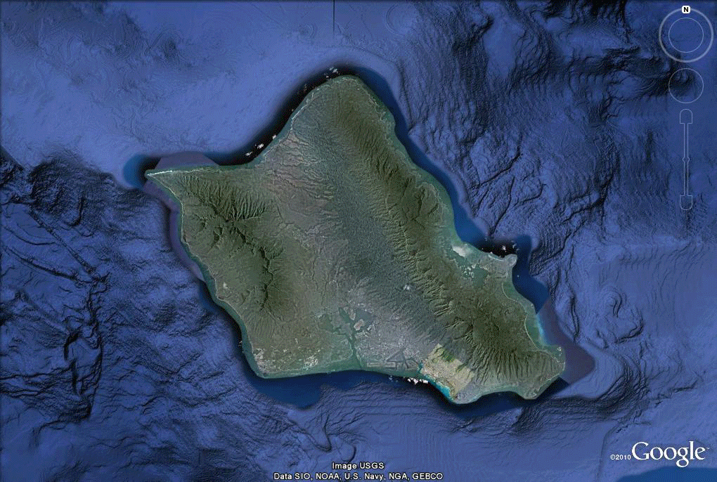 Figure 5. Oahu. Balloons indicate sites that are part of the mite inventory. Yellow means "no mites sighted" and red means "mites sighted." |
 Figure 6. Locations in eastern Kenya, from GPS data. |
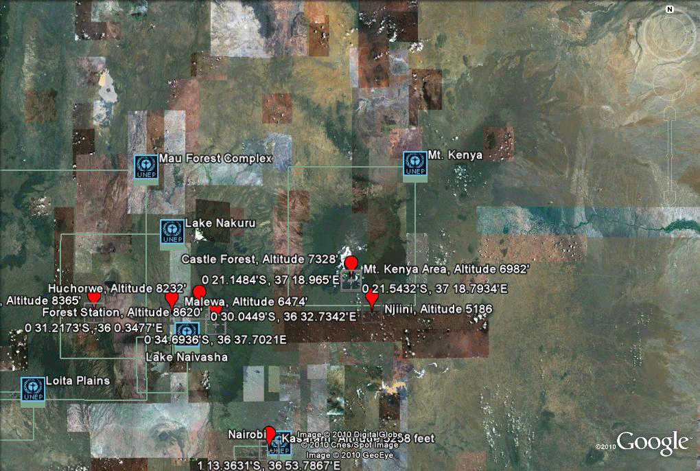 Figure 7. Mt. Kenya area supplemented with other data already onboard in Google Earth. |
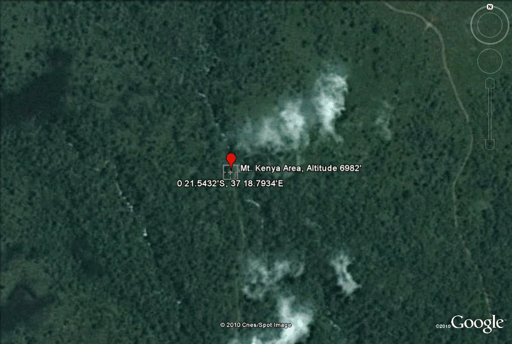 Figure 8. Three areas of change (boxes outlined in yellow) in the region surrounding Mt. Kenya. |
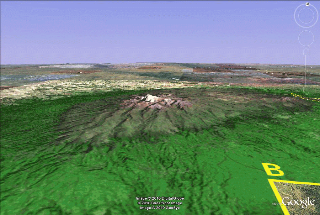 Figure 9. Ruggedness of terrain in the area around Mt. Kenya. |
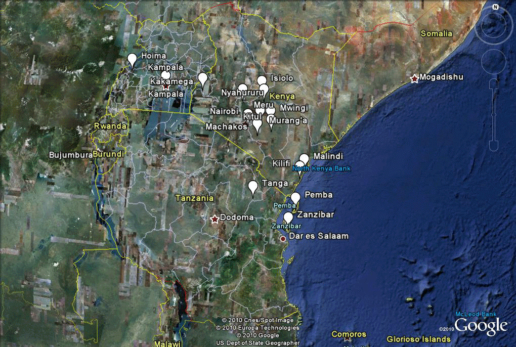 Figure 10. General data for Kenya, Uganda, and Tanganyika mapped in Google Earth from a paper map showing approximate locations of tested sites (Frazier et al., 2010). |
Figure 11. Travel with Varroa; maps at different scales legibly displayed together. |
Anderson,
D.L. and Trueman, J.W.H. 2000. Varroa jacobsoni
(Acari: Varroidae) is
more than one speices. Exp. Appl. Acarol. 24: 165-189.
Calderon,
Rafael A.; Ortiz, Alberto; Aparisio, Bolivar; and,
Ruiz, Maria Teresa. Varroa in
Panama: detection, spread and
prospects. DOI, Vo. 81 (3), 126-128.
Ellis,
J. D. and Munn, P. A.
2005. The worldwide health status of honey bees.
Bee World 86(4): 88–101
http://www.ibra.org.uk
Fakhimzadeh,
K.
Detection of major mite pests of Apis
mellifera and development of non-chemical control of Varroasis. Helsinki, 2001. Dissertation,
Univ. of Helsinki.
Frazier,
M.; Muli, E.; Conklin, T.; Schmehl, D.; Torto, B.;
Frazier, .J.; Tumlinson, J.; Evans, J.D.; and Raina, S. 2010. A scientific note on Varroa destructor found
in East Africa; threat or opportunity?
Apidologie 41 : 463-465. Online:
RA/DIB-AGIB/EDP Sciences, 2009 http://www.apidologie.org
DOI:
10.1051/apido/2009073
Free,
J. D. 1993.
Insect Pollination of Crops, 2nd edition.
Academic Press: London. 684ppg.
Google
Earth.
http://www.google.com/earth/index.html
Hallim,
M. K. I. 2000.
Pests and diseases of honeybees in Trinidad and Tobago in the
year 2000
and recommendations to reduce their spread in the Caribbean. Paper presented to the Second Caribbean
Beekeeping
Congress, Nevis, August 14-18, 2000.
Ministry of Agriculture Fisheries and Food, U.K.(1996) Varroosis
- a
parasitic infestation of honeybees.
Kunimoto,
S. L. Varroa Mite Survey, State of Hawaii, link.
Matheson,
A. 1996. World bee health update 1996. Bee World
77: 45-51.
McGregor,
1976.
Insect Pollination of Cultivated Crop Plants.
Agriculture Handbook No. 496. ARS-USDA,
Washington, DC. On line at: http://www.ars.usda.gov/SP2UserFiles/Place/53420300/OnlinePollinationHandbook.pdf
Navajas,
M., Anderson, D.L., De Guzman, L.I., Huang, Z.Y.,
Clement, J., Zhou, T., Le Conte, Y.
2010. New Asian types of Varroa destructor: A potential new
threat for
world apiculture. Apidologie, 41 (2):
181-193.
Neumann,
P., and J. D. Ellis. 2008. The small hive beetle (Aethina
tumida Murray, Coleoptera:
Nitidulidae): distribution, biology and control of an invasive species.
J.
Apic. Res. 47: 181-183.
Rosenkranz,
P., Aumeier, P., Ziegelmann, B. 2010. Biology
and control of Varroa destructor.
Journal of Invertebrate Pathology, 103 (SUPPL. 1): S96-S119.
Sammataro, D.,
Gerson, U., Needham, G. 2000. Parasitic mite
so honey bees: life history, implications and impact. Ann. Rev.
Entomol.
45:519-548.
| Solstice:
An Electronic Journal of Geography and Mathematics,
Volume XXI, Number 1 Institute of Mathematical Geography (IMaGe). All rights reserved worldwide, by IMaGe and by the authors. Please contact an appropriate party concerning citation of this article: sarhaus@umich.edu http://www.imagenet.org http://deepblue.lib.umich.edu/handle/2027.42/58219  |
 IMaGe logo designed
by Allen K. Philbrick from an original provided by the Founder. IMaGe logo designed
by Allen K. Philbrick from an original provided by the Founder.
|
|
Congratulations to all Solstice contributors. |
|
| Remembering those who
are gone now but who contributed in various ways to Solstice or to IMaGe
projects, directly or indirectly, during the first 25 years of IMaGe: Allen K. Philbrick | Donald F. Lach | Frank Harary | William D. Drake | H. S. M. Coxeter | Saunders Mac Lane | Chauncy D. Harris | Norton S. Ginsburg | Sylvia L. Thrupp | Arthur L. Loeb | George Kish | |