Latitude
and
Longitude
Figures and text
based on
images and text from a GeoSystems webpage which no longer
exists.
Permission was
granted for
an earlier use of selected images when the previous site was
contacted.
Consider the Earth to be modeled as a
sphere:
the Earthsphere. The Earth is not actually a sphere, but a
sphere
is a good approximation to its shape and the sphere is easy to
work with
using classical mathematics of Euclid and others.
-
Given a sphere and a plane.
There are
only a few logical possibilities about the relationship
between the plane
and the sphere.
-
The sphere and the plane do not
intersect.
-
The plane touches the sphere at
exactly one
point: the plane is tangent to the sphere.
-
The plane intersects the sphere.
-
and does not pass through the
center of the
sphere: in that case, the circle of intersection is
called a small
circle.
-
and does pass through the
center of the sphere:
in that case, the circle of intersection is as large as
possible and is
called a great circle.
-
Great circles are the lines along
which distance
is measured on a sphere: they are the geodesics on the
sphere.
-
In the plane, the shortest
distance between
two points is measured along a line segment and is unique.
-
On the sphere, the shortest
distance between
two points is measured along an arc of a great circle.
-
If the two points are not at
opposite ends
of a diameter of the sphere, then the shortest distance is
unique.
-
If the two points are at
opposite ends of
a diameter of the sphere, then the shortest distance is
not unique:
one may traverse either half of a great circle.
Diametrally opposed
points are called antipodal points: anti+pedes,
opposite+feet, as
in drilling through the center of the Earth to come out on
the other side.
-
To reference measurement on the
Earthsphere
in a systematic manner, introduce a coordinate system.
-
One set of reference lines is
produced using
a great circle in a unique position (bisecting the distance
between the
poles): the Equator. A set of evenly spaced
planes, parallel
to the equatorial plane, produces a set of evenly spaced
small circles,
commonly called parallels. They are called that
because it is the
planes that are parallel to each other.
-
Another set of reference lines is
produced
using a half of a great circle, joining one pole to another,
that has a
unique position: the half of a great circle that
passes through the
Royal Observatory in Greenwich, England (three points
determine a circle).
Here it is historical consideration that produces the
uniqueness in selection.
Choose a set of evenly spaced halves of great circles
obtained by rotating
the diametral plane along the polar axis of the Earth.
These lines
are called meridians: meri+dies=half day, the
situation of the Earth
at the equinoxes (see page on seasons).
The
unique line is called the Prime Meridian; other halves of
great circles
are called meridians.
This particular reference system for
the Earth
is not unique; an infinite number is possible. There is
abstract
similarity between this particular geometric arrangement and the
geometric
pattern of Cartesian coordinates in the plane.
-
To use this arrangement, one
might describe
the location of a point, P, on the Earthsphere as
being at the 3rd
parallel north of the Equator and at the 4th meridian to the
west of the
Prime Meridian. While this might serve to locate P
according
to one reference system, someone else might employ a
reference system with
a finer mesh (halving the distances between success lines)
and for that
person, a correct description of the location of P
would be at the
6th parallel north of the Equator and at the 8th meridian to
the west of
the Prime Meridian. Indeed, an infinite number of
locally correct
designations might be given for a single point: an
unsatisfactory
situation in terms of being able to replicate results.
The problem
lies in the use of a relative, rather than an absolute,
locational system.
-
To convert this system to an
absolute system,
that is replicable, employ some commonly agreed upon
measurement strategy
to standardize measurement. One such method is the
assumption that
there are 360 degrees of angular measure in a circle.
-
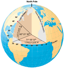
Thus, P might be
described as lying
42 degrees north of the equator, and 71 degrees west of
the Prime Meridian.
The degrees north are measured along a meridian; the
degrees west are measured
along the Equator or along a parallel (the one at 42 north
is another natural
choice). The north/south angular measure is called
Latitude; the
east/west angular measure is called Longitude.
-
The use of standard circular
measure creates
a designation that is unique for P; at least
unique to all whose
mathematics rests on having 360 degrees in the circle.
Parts of degrees may be noted as
minutes
and seconds, or as decimal degrees. A degree (°) of latitude
or longitude
can be subdivided into 60 parts called minutes ('). Each
minute can be
further subdivided into 60 seconds ("). Thus, 42
degrees 30 minutes
is the same as 42.50 degrees because 30/60 = 50/100.
Current computerized
mapping software often employs decimal degrees as a default;
older printed
maps may employ degrees, minutes, and seconds. Thus,
the human mapper
needs to take care to analyze the situation and make
appropriate conversions
prior to making measurements of position. Such
conversion is simple
to execute using a calculator. For example, 42 degrees
21 minutes
30 seconds converts to 42 + 21/60 +30/3600 degrees =
42.358333 degrees;
powers of ten replace powers of 60.
-
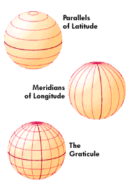
The figure below shows the
reference system
described above placed on a sphere. What might be called
a Cartesian
grid in the plane is called a graticule on the sphere.
-
All parallels have the same
latitude; they
are the same distance above or below, north of or south of,
the Equator.
-
All meridians have the same
longitude; they
are the same distance east or west of the Prime Meridian.
-
Spacing between successive
parallels or meridians
might be at any level of detail; however, when circular
measure describes
the position of these lines, that description is unique up
to agreement
to use 360 degrees in a circle. One spacing for the
set of meridians
that is convenient on maps of the world, is to choose
spacing of 15 degrees
between successive meridians. The reason for this is
that since the
meridians converge at the ends of the polar axis, that each
meridian then
represents the passage of one hour of time. Given that
we agree to
partition a day into 24 hours, 24 times 15 is 360, meridians
may also mark
time.
-
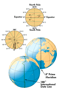
Bounds of measurement (see the
figure below).
-
Latitude runs from 0° at the
equator to
90°N or 90°S at the poles.
-
Longitude runs from 0° at the
prime meridian
to 180° east or west, halfway around the globe. The
International Date
Line follows the 180° meridian, making a few jogs to avoid
cutting
through land areas.
-
Length of one degree on the
Earthsphere.
-
One degree of latitude, measured
along a meridian
or half of a great circle, equals approximately 69 miles
(111 km). One
minute is just over a mile, and one second is around 100
feet (a pretty
precise location on a globe with a circumference of 25,000
miles).
Calculation: 25,000/360 = 69.444.
-
Because meridians converge at the
poles, the
length of a degree of longitude varies, from 69 miles at the
equator to
0 at the poles (longitude becomes a point at the
poles). Calculation:
at latitude theta, find the radius, r, of the parallel,
small circle, at
that latitude. The radius, R, of the Earthsphere is R
= 25,000 /
(2*pi)=3978.8769 miles. Thus, cos theta = r/R (using a
theorem of
Euclid that alternate interior angles of parallel lines cut
by a transversal
are equal). Therefore, r=R cos theta. Then, the
circumference
of the small circle is 2r*pi and the length of one degree at
theta degrees
of latitude is 2r*pi / 360. For another application of
this particular
theorem of Euclid, see the linked
page concerning Eratosthenes measurement of the
Earthsphere.
-
For example, at 42 degrees of
latitude, r
= 2956.882. Thus, the circumference of the
parallel at 42 degrees
north is approximately 18578.6205 miles. Thus, the
length of one
degree of longitude, measured along the small circle at 42
degrees of latitude,
is: 51.607 miles.
-
This particular calculation
scheme is a rich
source of elementary problems using geometry and
trigonometry. Consider
the following question: at what latitude is the
length of one degree
on longitude exactly half the value of one degree of
longitude at the equator?
-
Readers wishing a visual review
of trigonometry
may find this link to be
of use.
-
The position of the sun in the
sky.
On June 21, the direct ray of the sun is overheard, or
perpendicular to
a plane tangent to the Earthsphere, at 23.5 degrees north
latitude (link
to page about seasons). The angle of the sun in the sky
at noon on
that day is 90 degrees. What is the angle of the sun in
the sky,
at noon on June 21, at 42 degrees north latitude? Again,
simple geometry
and trigonometry solve the problem for this value and for any
other.
Use the fact that 42-23.5=18.5 degrees; that there are 180
degrees in a
triangle (look for a right triangle with the right angle at 42
degrees
north latitude); and that corresponding angles of parallel
lines cut by
a transversal are equal. The answer works out to be 71.5
degrees.
Thus, on June 21 at local noon, in the northern hemisphere at
42 degrees
north latitude the sun will appear in the south at 71.5
degrees above the
horizon; in the southern hemisphere at 42 degrees south it
will appear
in the northern sky at 71.5 degrees above the horizon.
Between the
tropics, some interesting situations prevail (link to Parallels
between Parallels, pages 74-86, IMaGe Monograph
13). Use of this technique is important
in calculating shadow and related matters in electronic
mapping:
it was employed in making several virtual reality models of in
this book.
Further Directions:
-
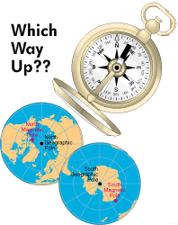
The north and south poles are the
earth's
geographic poles, located at each end of its axis of rotation.
All meridians
meet at these poles. The compass needle points to either of
the earth's
two magnetic poles. The north magnetic pole is located in the
Queen Elizabeth
Islands group, in the Canadian Northwest Territories. The
south magnetic
pole lies near the edge of the continent of Antarctica, off
the Adélie
Coast. The magnetic poles are constantly moving.
What are the
implications of this fact for the stability of our graticule?
-
All of our geometric analysis is
based on
Euclidean geometry, assuming Euclid's Parallel
Postulate: given a
line and a point not on the line--through that point there
passes exactly
one line that does not intersect the given line.
Non-Euclidean geometries
violate this Postulate. What does the geometry of the
Earthsphere
become in the non-Euclidean world?
Institute
of Mathematical Geography. Copyright, 2005, held by
authors.
Spatial
Synthesis:
Centrality and Hierarchy, Volume I, Book 1.
Sandra Lach Arlinghaus
and
William Charles Arlinghaus