 |
 |
Allen's Creek is a tributary of the Huron
River, which bisects Ann Arbor, Michigan, into north and south sides. Allen's
creek rises on the south side of Ann Arbor. It flows north to the Huron
past residential neighborhoods near the University of Michigan stadium
as well as past residences, businesses, and industries in the downtown
and nearby west side areas. For much of its length, Allen's Creek is confined
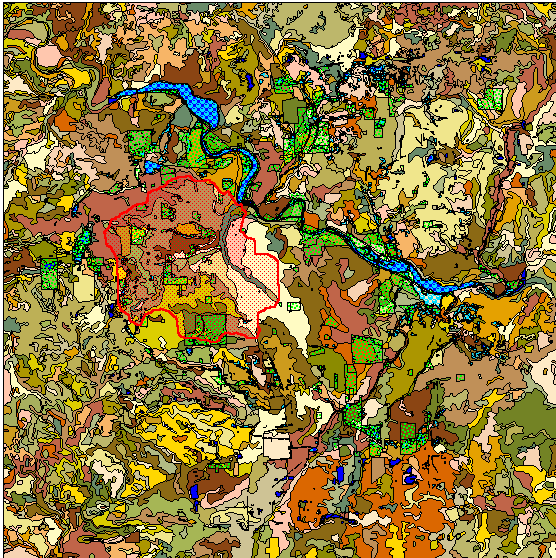
in an underground pipe. The sequence of maps shown below, in Figure 1 (left),
shows the outline of the creek shed in red (with a stippled red pattern
inside the creek shed). The backdrop behind the creek shed shows
surface hydrology (shades of blue), parks (green pattern), street pattern,
and soil types (shades of earth tones). This sequence is presented,
as an animated abstract, to suggest some elements of the complexity of
this particular creek shed. A more detailed picture of complexity would
need to reflect the degree of accuracy of the maps: flood plain boundaries
are plus or minus 40 feet, contours are plus or minus 5 feet, and so forth.
The flood plain is the area into which water spills out when the creek
rises out of the flood way--the direct channel containing the surging water.
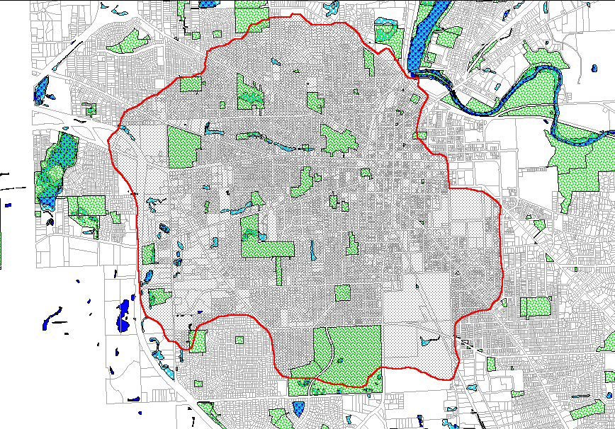
The map to the right of the animated map is a static close-up of the same
region; it shows the parcel map (Figure 1, right).
|
|
Figure 1. Left: Animated abstract, to illustrate some of the complexity, of the Allen Creek shed showing surface hydrology, parks, streets, and soils. Right: Static close-up of Allen Creek shed, parks, surface hydrology, and City parcels.
The animated abstract and static maps in
Figure 1 show only surface hydrology at a gross level; Allen's Creek, itself,
is not evident within the water shed. The animated map sequence in
Figure 2 shows Allen's Creek, its flood plain, the City parcel map and
clipped portions of the parcel map (the theme of shades of yellow is based
on parcel size; it could be based on any information for which data was
available). Depending on how the clipping is done, various pictures
are portrayed. The first clip truncates parcels in the flood plain
with the flood plain boundary. Thus, one does not know how much of any
particular parcel lies in the flood plain and therefore that view is supplemented
with a grayed backdrop of the entire parcel map. More effective,
from a standpoint of parcel percentage within the flood plain, is to select
all parcels from the parcel map that touch the flood plain boundary.
The resulting map is then one that overlaps the flood plain boundary.
Yet another parcel map can be created if the creek itself is used, rather
than the flood plain, to create such maps. All maps in this sequence
have merit; yet which one might a municipality choose to use as a policy
statement from which to help in allocation of funds? Each will lead the
community in different directions. The different maps shown in Figure
2 select different sets of parcels as "flood plain parcels." Planners
of all sorts (professionals and others) should consider this fundamental
issue prior to allocating tens of millions of taxpayer dollars for improvements.
The maps we draw influence the decisions we make; the decisions we make
influence the maps we draw. Maps and decisions, together, influence
the conclusions we draw and the policies we make.
 |
Figure 2. Animated map sequence of different styles of maps that might be made employing Allen Creek, Allen Creek flood plain, and City of Ann Arbor parcels. Which parcel map clipped by hydrology might be viewed as the "official" statement--all have merits and drawbacks and each one selects a set of parcels different from the other.
If one owns the GIS used to make the maps and has access to the base maps, then it is a relatively straightforward matter to create a variety of maps and consider the merits and drawbacks of each. The average taxpayer, however, may not own such software. How, then, might that person, who wishes to participate in a public process, do so? One answer is to distribute the materials using the Internet in such a way that not only can already-prepared maps be distributed, but so, too, can some of the capability of the GIS software be distributed through free software, such as a browser. The linked map shows an Internet map of Allen's Creek and its flood plain. It also shows the City parcel map and street centerlines; the map has some degree of user interaction available. Use the inset map as a context guide; zoom in on the large map; and, use the inset map to navigate around the large map (click on the inset map to do so). Click on the large map to bring up the database that is interactive with the map.
The interactive, online linked map is created using ImageMapper (TM) software applied to maps made in ArcView GIS 3.2 (TM, ESRI) from City of Ann Arbor base maps. The material that is put into the internet map is, of course, the choice of the person who owns the mapping software and the server account on which such maps are distributed. Internet mapping is attractive for a variety of eGovernment possibilities (Randy Deshazo, student College of Architecture and Urban Planning, University of Michigan, first drew my attention to these maps as useful for eGovernment interaction).
Opportunity
As a city, Ann Arbor is reliant on (among
other things) taxpayer dollars to keep the City going. The University contributes,
of course, to opportunities of various sorts, but as a state university
does not contribute directly to the tax base. Thus, the tax base that is
drawn upon comes from an unusually small percentage of land within the
city: Ann Arbor has high property tax rates in relation to other
Michigan cities. Most of the land within the city is already developed.
One way to continue to raise funds is to do so through dollars from developers.
With sky-rocketing property values, and little available land, developers
turn an eye to creative uses of existing land within the city. Some proposals
are sensitive to environmental costs; others are less so. Some see Allen's
Creek flood plain and flood way as a source of substantial tracts of
land that they believe could be successfully developed, sometimes citing
arguments that promoting density in the downtown area (where there is substantial
existing infrastructure) can reduce sprawl. For them, the flood plain and
flood way offer opportunity: their arguments are often couched in terms
that suggest opportunity for others as well (sprawl reduction through promoting
density, affordable housing, or needed dollars for the city). Peter
Allen, local real estate developer and University of Michigan colleague,
comments in a note to James Nicita (Allen's Creek Watershed Group and Wayne
State University) that we keep in mind the following items:
"1) An engineering study should include an economic study. The repair and redevelopment of the Allen Creek must look at the options for new construction wherever possible, partly to serve the demand for not only open space but also for office, housing, neighborhood retail, artists, non-profits, etc.Ordinances may be revised to allow extra height in exchange for donation of flood plain and flood way segments of existing parcels to parkland: to create continuous build-up of green space for natural hydrological and biological activity. This approach is just one example of a strategy that may have merit. No matter how the issue is argued, however, it is clear that there are substantial economic benefits, to businesses and to the broader community (in terms of wise expenditure of the tax base), to developing and redeveloping parcels of land already in the City. The challenge is to do so in a manner that does not add to the existing environmental burden and to do so in a manner that will help to remedy that burden.
2) ...improvements will cost $80 million according to one study. Who will pay for this? Creating a[n]... overlay district to capture the taxes from the new development should be considered.
3) Allen Creek goes under several buildings...Daylighting is not an option in places such as this.
4) Keep in mind that the city is the biggest landowner in the creekway...."
Disaster
On the other side of the issue are environmental
arguments. Should one ever build in the flood plain or flood way? These
belong to the river and the river will take and use them whenever it needs
to do so. To build in them is to offer eventual disaster to residences
and businesses located in them. There are already hundreds of structures
in the Allen Creek flood plain or flood way (Ann Arbor Observer,
November, 1999). To build new structures may increase the threat to those
already there. Because Allen's Creek is confined within a pipe in the more
densely built-up areas of town, there are already reports of spectacular
events with manhole covers over Allen's Creek popping like corks during
heavy rains (interview of Ethel Potts long-time city resident; also, Ann
Arbor Observer, November, 1999). The extreme position here might see
removal of all structures from the flood plain and flood way parcels, conversion
of them into parkland that could serve as a buffer between adjacent non-flood
plain properties, and an unearthed ("daylighted") Allen's Creek allowed
to follow its natural channel. City of Ann Arbor Planning Director, Karen
Popek Hart, notes, however, that "a huge issue...is contamination of soil
the pipe lies in--daylighting may not be environmentally 'good' without
massive excavation and disposal." If the economic issues dominate,
might they tend only to defer the inevitable long-range environmental issues?
In the total build-out scenario, after all the flood plains and flood ways
are built upon, what next? Redevelopment of parcels offers one promise
for continuing funds and if the environmental issues dominate, such sources
of funding will be sorely needed.
Conclusion
This local issue points to an obvious
need to reconcile economic and environmental needs, not as separate issues
but as the complexly intertwined knot of challenges that they are.
Viewed more broadly, this local controversy might be seen as a difference
in reconciling issues involving long-range and short-range planning. Central
to many arguments is a "belief" as to whether the worst case (or even bad
case) environmental scenario can occur. This "belief" often rests on maps:
what is a flood plain and do the maps represent the situation in a realistic
fashion? Some say no: the evidence of experience is what should guide land
use. Others say yes: the map is a scientific tool that is applied uniformly
across the city and does not play neighborhood favorites (Ann Arbor
Observer, November, 1999). The heart of the matter is to determine
what constitutes a highest and best use of tax payer dollars--one simply
cannot know in advance, despite highly persuasive arguments advanced on
all sides. Thus, a middle of the road action might arise as the prudent
political action--as so often seems to happen in situations involving dilemmas.
Factors that might play into an answer to reconciling the disaster with the opportunity include (but are not limited to):